Contact Info
DOMAINES DE COMPETENCE
- Hydrology - hydrologie
- Numerical modelling - modélisation numérique
- Remote sensing - télédétection
RESUME
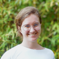
Christina Orieschnig est ingénieure de recherche en hydrologie, spécialisée dans la modélisation numérique et la télédétection, notamment à l'aide de Sentinel-1 et -2 ainsi que des données Landsat, CHIRPS et MODIS. Elle s'intéresse particulièrement à l'intégration des composantes du cycle de l'eau obtenues par télédétection dans la modélisation hydrologique, ainsi qu'à la synthèse des données satellitaires et in situ. Sa thèse portait sur une approche interdisciplinaire visant à comprendre le système des canaux de Prek dans le delta du Mékong cambodgien, à l'aide d'enquêtes auprès des parties prenantes, de recherches dans les archives, de la télédétection et de la construction d'un modèle en Python.
Pendant et après sa thèse, elle a enseigné au niveau BSc et MSc à l'Université de Montpellier, à AgroParisTech et à l'Institut Agro, avec des cours allant des mathématiques et de l'hydraulique à la métrologie et au codage en R.
Elle s'intéresse également à la communication scientifique, à la fois pour un public spécialisé et pour un public plus large. Elle dirige le groupe de travail sur la communication de la nouvelle décennie "Science for Solutions" de l'Association internationale des sciences hydrologiques (AISH) et représente les scientifiques en début de carrière de la division des sciences hydrologiques de l'Union européenne des géosciences (EGU).
-------------------------------------
Christina Orieschnig is a research engineer in hydrology who specialises in numerical modelling and remote sensing, especially using Sentinel-1 and -2 as well as Landsat, CHIRPS, and MODIS data. Her particular interest lies in the integration of remotely sensed water cycle components into hydrological modelling, as well as the synthesis of satellite and in-situ data. Her thesis focused on an interdisciplinary approach to understanding the system of Prek channels in the Cambodian Mekong Delta, using stakeholder surveys, archival research, remote sensing, and the construction of a custom-tailored model in Python.
During and after her thesis she taught at both BSc and MSc level at the University of Montpellier, AgroParisTech, and the Institut Agro, with courses ranging from mathematics and hydraulics to metrology and coding in R.
Her other major interest lies in science communication, both to a specialised and a broad audience. She’s the leader of the Communication Working Group of the International Association of Hydrology Sciences’s (IAHS) new Science for Solution Decade as well as the Early Career Scientist (ECS) representative for the Hydrological Sciences Division of the European Geosciences Union (EGU).
FORMATION
2011-2015: BA in English and BSc in Biology at the University of Vienna, Austria
2015-2018: MSc in Biodiversity Management at the University of Vienna and MSc in Civil Engineering with a specialisation in hydrology, hydraulics, and geotechnics at the University of Natural Resources and Life Sciences (BOKU) in Vienna
2018-2022: PhD at AgroParisTech (Centre Montpellier), UMR G-EAU, and the École Doctorale GAIA
PRINCIPALES PUBLICATIONS
ORCID: https://orcid.org/0000-0001-5182-7110
- Articles
-
Orieschnig, C.A., Cavus, Y., 2023. Spatial characterization of drought through CHIRPS and a station-based dataset in the Eastern Mediterranean. In Proceedings of the International Association of Hydrological Sciences.
-
Orieschnig, C.A., Venot, J.P, Massuel, S., Eang, K.E., Kong, C., Lun, S., and Belaud, G., 2022. A Multi-Method Approach to Flood Mapping: Reconstructing Inundation Changes in the Cambodian Upper Mekong Delta. Journal of Hydrology, p.127902.
-
Orieschnig, C.A., Venot, J.P, Massuel, S., Eang, K.E., Kong, C., Lun, S., and Belaud, G., 2022. A Dataset for the assessment of changes in the incidence, extents, and spatial patterns of inundations in the Cambodian Mekong Delta, based on a water level - flood link calculated from in-situ water levels, and Sentinel-derived inundation maps. Data in Brief, p. 108469.
-
Orieschnig, C.A., Belaud, G., Venot, J.P., Massuel, S. and Ogilvie, A., 2021. Input imagery, classifiers, and cloud computing: Insights from multi-temporal LULC mapping in the Cambodian Mekong Delta. European Journal of Remote Sensing, 54(1), pp.398-416.
- Communications
-
Orieschnig, C.A., Belaud, G., Massuel, S. and Venot, J.P., 2023, April. Agro-ecological impact assessment of irrigation canal rehabilitation scenarios under different hydrological conditions in the upper Mekong Delta, Cambodia. EGU General Assembly. Vienna, Austria.
-
Orieschnig, C.A., Cavus, Y., 2022, June. Spatial characterization of drought through CHIRPS and a station-based dataset in the Eastern Mediterranean. IAHS Scientific Assembly Montpellier, France.
-
Orieschnig, C.A., Belaud, G., Massuel, S. and Venot, J.P., 2022, June. Retro- and forecasting inundation extents for trend analysis in the Cambodian Mekong Delta - a new method combining Sentinel-1 and 2 and local water level measurements. IAHS Scientific Assembly Montpellier, France.
-
Orieschnig, C.A., Belaud, G., Massuel, S. and Venot, J.P., 2022, May. Irrigation canal systems of the Cambodian Mekong delta: Assessing changes in ecosystem services for rural communities after wide-ranging rehabilitation plans. EGU General Assembly. Vienna, Austria.
-
Orieschnig, C.A., Belaud, G., Massuel, S. and Venot, J.P., 2021, April. Cultivated floodplains of the Cambodian Mekong delta: understanding the changing balance between the flow regime and the agricultural practices. EGU General Assembly. Vienna, Austria.
-
Orieschnig, C.A., Belaud, G., Massuel, S. and Venot, J.P., 2020, May. Irrigation canal systems of the Cambodian Mekong delta: Assessing changes in ecosystem services for rural communities after wide-ranging rehabilitation plans. EGU General Assembly. Vienna, Austria.
-
Orieschnig, C.A., Belaud, Ogilvie, A. and Venot, J.P., 2019, July. Combining Optical and SAR Remote Sensing Approaches for Optimal Flood Mapping in the Mekong Delta, Cambodia, using Google Earth Engine. IUGG General Assembly. Montreal, Canada.


