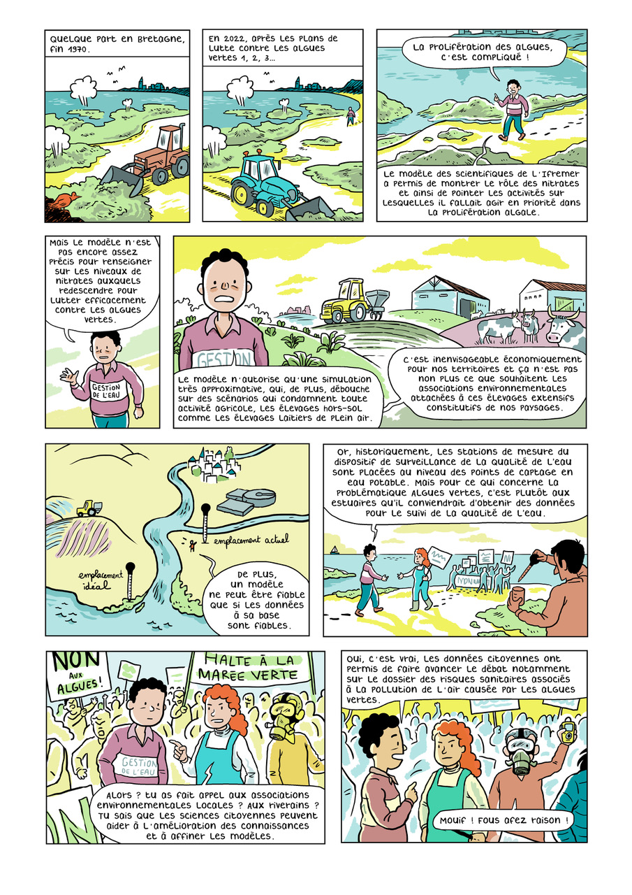
Le Vendredi Découverte du vendredi 06 juin 2025 a été consacré à une séance spéciale Axe 3 - Cette séance porte sur la présentation d’une des 15 planches de BD qui alimenteront le futur ouvrage dans le cadre de l’axe 3 : Informations, Incertitudes, Décisions. Elle vise la mise en discussion du message porté par cette BD et invite chacun à se positionner en rapport avec ses propres recherches. La discussion est ouverte à tous.

Thème de la séance : « Une bonne eau : une eau qui vit ! », planche présenté par Caroline Lejars et Olga Peytavi.


Dans le cadre du projet GOUTTE (https://www.cresica.nc/projet/goutte), Caroline Lejars a souhaité partager son expérience en Nouvelle Calédonie relative aux différentes perceptions de la qualité de l’eau en lien avec les solutions de gestion (co-auteurs : Olga Peytavi, Severine Bouard et Pierre Yves Le Meur).

David Dorchies sera dans un premier temps rapporteur de cette planche, puis Caroline nous présentera le message qu’elle a voulu transmettre. Enfin, une discussion sera ouverte à tous les participants qui seront libres d’exprimer leurs ressentis ainsi que les expériences ou travaux auxquels cela fait écho. 


Vous êtes invités à prendre connaissance de la planche ci-après :

bd eau qui vit

Cette thèse s'inscrit dans lle cadre du projet DESIRA RAIZ qui a pour but d'accompagner les agriculteurs du Zimbabwe vers une intensification écologique. Pour se faire, il est nécessaire de connaitre et de comprendre les préférences technologiques des agricuteurs ainsi que leurs contraintes. En effet, pour proposer des politiques publiques adaptées aux besoins des agriculteurs, l compréhension des processus de décision des exploitants est requise. L'hypothèse principale de cette recherche est que les caractéristiques des instruments et des technologies sont déterminantes dans la décision d'adoption des agriculteurs.

Cette thèse mobilise principalement des méthodes d'économie expérimentale et s'organise en trois phases. La première cibsiste à découvrir le terrain et à collecter des données afin d'établir une typologie des exploitations de la région d'éude. Ensuite, pour parfaire notre compréhension du terrain et de la population visée, une expérience de choix discret prendra place. Cette méthode de préférence déclare a pour but d'identifier clairement les caractéristiques "idéales" de la technologie ou de l'instrument du point de vue des agriculteurs. Enfin, afin de vérifier les hypothèses développées dans la phase précédent, un essai contrôlé randomisé sera implémenté. Ce type d'expérience teste la valiité et l'impact de la technologie ou instrument choisi sur un échantillon d'exploitans. 


Mots-clés : préférences - économie expérimentale - expériences de choix discret - essai contrôlé randoisé - typologie des exploitations - Zimbabwe - instrument - technologie - pratiques agricoles

photo Dominguez © Photo : Juan Dominguez 2021 - Culture de maïs irrigué en agriculture de conservation des sols

En région méditerranéenne, le changement climatique intensifie les épisodes de sécheresse et élève les températures, aggravant l’évapotranspiration des cultures et altérant le bilan hydrique des sols. L’agriculture de conservation des sols (ACS) est une approche prometteuse qui, à long terme, renforce la résilience des sols en réduisant leur dégradation.

Lors du Vendredi Découverte du vendredi 23 mai 2025, Sandra Lanini nous a présenté le sujet suivant : AXE3 / BD "Etudes successives sur l'impact du changement climatique - Comment communiquer des résultats contradictoires ?"


Attention séance spéciale Axe 3 - Cette séance porte sur la présentation d’une des 15 planches de BD qui alimenteront le futur ouvrage dans le cadre de l’axe 3 : Informations, Incertitudes, Décisions. Elle vise la mise en discussion du message porté par cette BD et invite chacun à se positionner en rapport avec ses propres recherches. La discussion est ouverte à tous. 

Thème de la séance : « Prévoir la pluie et le beau temps », planche présentée par Sandra Lanini. 

Dans le cadre du projet Explore2, Sandra Lanini a souhaité aborder le sujet de la modélisation de l’impact du changement climatique sur les ressources en eau. (co-auteurs : Yvan Caballero, Benoit Hingray et Eric Sauquet). 

Bruno Bonté sera dans un premier temps rapporteur de cette planche, puis Sandra nous présentera le message qu’elle a voulu transmettre. Enfin, une discussion sera ouverte à tous les participants qui seront libres d’exprimer leurs ressentis ainsi que les expériences ou travaux auxquels cela fait écho.

Lors du Vendredi Découverte du vendredi 16 mai 2025, Hind Oubanas nous a présentéle sujet suivant : SWOT - Discharge from Reach to Basin Scale

SwotDischargeFromReachToBasinScale 

Résumé : Modeling river discharge at a global scale is vital for understanding water fluxes, managing water resources, and mitigating flood risks. Traditionally, hydraulic and hydrological models have depended on in-situ observations collected at strategic points along major rivers and their tributaries. These ground-based measurements are essential for calibrating and validating models, ensuring that the simulated discharge closely aligns with observed river flows. However, river gauges have inherent limitations, including sparse spatial coverage and a decline in availability due to practical, economic, or political factors.

Remote sensing has emerged as a transformative tool to address these challenges, providing systematic observations over extensive regions. Various methods have been developed to estimate river discharge using satellite data, typically requiring calibration with ground-based data or models. The launch of the Surface Water and Ocean Topography (SWOT) satellite mission in December 2022 marked a significant advancement in surface hydrology, particularly for discharge retrievals. SWOT employs two Synthetic Aperture Radar antennas to provide the first-ever concurrent two-dimensional, high-resolution measurements of water surface elevation and extent in rivers, lakes and wetlands. These measurements can offer a new perspective on how surface water is monitored and quantified, with initial results suggesting that SWOT is capable of meeting and even exceeding its science requirements. Among the products of the SWOT mission is a river discharge estimate, the first global discharge mission product. It is produced through operational discharge estimation algorithms that leverage the unique capability of the satellite to simultaneously observe river water surface elevation, width, and slope. Discharge algorithms solve hydraulic inverse problems at the reach scale, approximately every 10 km, as defined by the SWOT River Database hydrographic network, where the satellite observes the river during each overpass. The wide-swath nature of SWOT offers a fundamentally novel discharge product, providing comprehensive spatial coverage.

In this presentation, we first analyze SWOT discharge product and its spatiotemporal patterns across entire basins, such as the Mississippi, a well-monitored basin, the Congo, a poorly gaged basin and the Mekong, a transboundary basin. We will focus on the discharge algorithm, SIC4DVAR, one of the six official SWOT algorithms, developed by INRAE’s team. We will present the latest available discharge products, discussing their spatiotemporal coverage and the status of validation at the time of the meeting. Our focus will be on the product derived from the nominal orbit with a 21-day cycle, which provides global coverage. Differences between the constrained and unconstrained products will be explored. Preliminary results have also examined the impact of data quality filters on discharge performance, showing that stricter filters bring performance closer to pre-launch expectations. Remaining challenges related to data and algorithms will be discussed.

Next, we extend SWOT discharge's capabilities from the reach to the basin level. The analysis at the basin scale reveals sub-daily coverage of basins from upstream to downstream, with different overpasses capturing multiple tributaries simultaneously, thereby enabling a comprehensive examination of discharge variability in space and time. Next, we enhance large-scale basin discharge estimation by assimilating SWOT reach-scale data into the RAPID river network model. For the Mississippi basin, SWOT observes the basin an average of three times daily, with each overpass covering different rivers and tributaries. This assimilation process leverages SWOT's spatial and temporal coverage to integrate observed and propagated dynamics within a single cycle. Preliminary results indicate that while SWOT directly observes 10% of the basin, assimilation propagates this information to 82% of the basin, including unobserved tributaries. These findings demonstrate that integrating data assimilation, river modeling, and scaling can overcome temporal and spatial coverage limitations, significantly enhancing our ability to estimate basin-scale discharge.

Lors du Vendredi Découverte (normalement prévue le 2 mai) du mardi 29 avril 2025, à 11h.

Frédéric Grelot nous a présenté un travail intitulé : Residents' adaptation to flooding: A response to institutional injunctions or way to construct place


Résumé : Residents of areas exposed to flooding are subject to injunctions to adapt on the part of institutions. In France, over the last thirteen years or so, these have taken the form of incentive policies, successive versions of which aim to gradually remove the obstacles perceived by the institutions: lack of motivation, lack of knowledge, lack of resources. In this article, we show that careful observation of an area can put this institutional vision into perspective.

The observations used come from the so-ii observatory, centred around the urban area of Montpellier (a Mediterranean city in the south of France) and are based on two data collection methods. In this area, repeated field survey campaigns are used to complete a systematic inventory of devices used to close building openings. These campaigns were carried out across the whole of the area, without making any assumptions about the possibility of flooding occurring. In addition, qualitative interviews were conducted with around twenty residents who agreed to work in partnership with the observatory. These interviews focused on the adaptations made to their homes, put into perspective with their attachment to their living environment.

These observations show that the protection devices observed are present in many areas of the territory, without necessarily corresponding to those identified by the risk managers. Discussions with local residents provide a complementary picture of the adaptations made, which were put in place before the risk managers' incentive policies began, without any public funding. They can take many forms, from the most expected (by the institutions) to the most surprising. They can be genuine "cobbled-together innovations" when, in particular, technical or financial constraints seem insurmountable. Attachment to the place where we live is a key factor in motivating us to make these adaptations. Finally, the implementation of these adaptations is part of a set of practices that determine both their effectiveness and their durability.

In the end, we show that there are still major discrepancies between institutional expectations and residents' practices, which may call into question the relevance of incentive policies.

Page 2 sur 49
FaLang translation system by Faboba
APT Logo fra      logo brgm web frlogo inraeLogo Institut Agro Mpl petit


Enregistrer

Enregistrer

Enregistrer

Enregistrer

Enregistrer

Enregistrer